|
|
In case you hadn't been being attention (as usual), I would just like to reiterate (or for those who missed it completely, just iterate) St. Ives is bloody awful at the height of the season. You've got more chance pf getting a bit of peace and quiet on the central reservation of the M6! So, for those who fancy a change of scenery, a spot of exercise or just to exorcise the St. Ives demons of noise, rudeness and slobberiness here is how to do it. The Spooky St. Ives guide to THE place to be in St. Ives at the height of the summer ..... i.e. not in St. Ives at all. Tonight, Matthew, we will be mostly chilling out at The Engine Inn Okey pokey. There are several ways of doing this so here are the maps first and you can decide for yourselves which approach to take.
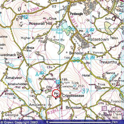
So, where's it at? Cripplesease. Y' wha'? I hear the uninitiated cry. Aye, Cripplesease, lad. If you don't know it, it is on the old road to Penzance, past Halsetown. Up on that hill with the ruined 'castle' on it that you've been eyeing up ever since you arrived in St. Ives. Should you be of a bone idle disposition (or en route elsewhere) it is about a five minute drive out of the top of St. Ives. Alternatively, you can go for a pleasant country walk to get there. There are various routes you can take, of which more soon. However, we do not recommend that you walk the main road to get there. The road gets very busy in the summer and the traffic tends to hurtle along at alarming speeds. The road is quite narrow and twisty with a number of blind corners and is often closed in on either side by hedges and/or ditches. This means that you can quite easily find yourself facing an oncoming truck with a coach coming the other way and nowhere for you to go (other than the afterlife) if one of them doesn't give way! So, if you are going to walk, take the scenic route (scenery provided free of charge by the locals). Before we set off it might be a good idea for you to scope out the Rosewall Hill section which covers the some of the same ground (especially the routes to Towednack). It also shows you where the trail kicks off. |
| I (that’s me) own the copyright in all the content of this site (except where otherwise acknowledged). You can read it, download it, transmit it and reproduce it only for your own personal use. You are not allowed to bugger about with it. If your computer explodes as a result of accessing this site and its contents, it’s nothing to do with me, mate! Copyright Vile Jelly Publications 2001-2009. All rights (and some wrongs) reserved. |