| Street |
Grid Reference |
Comments (if any) |
| Academy Place |
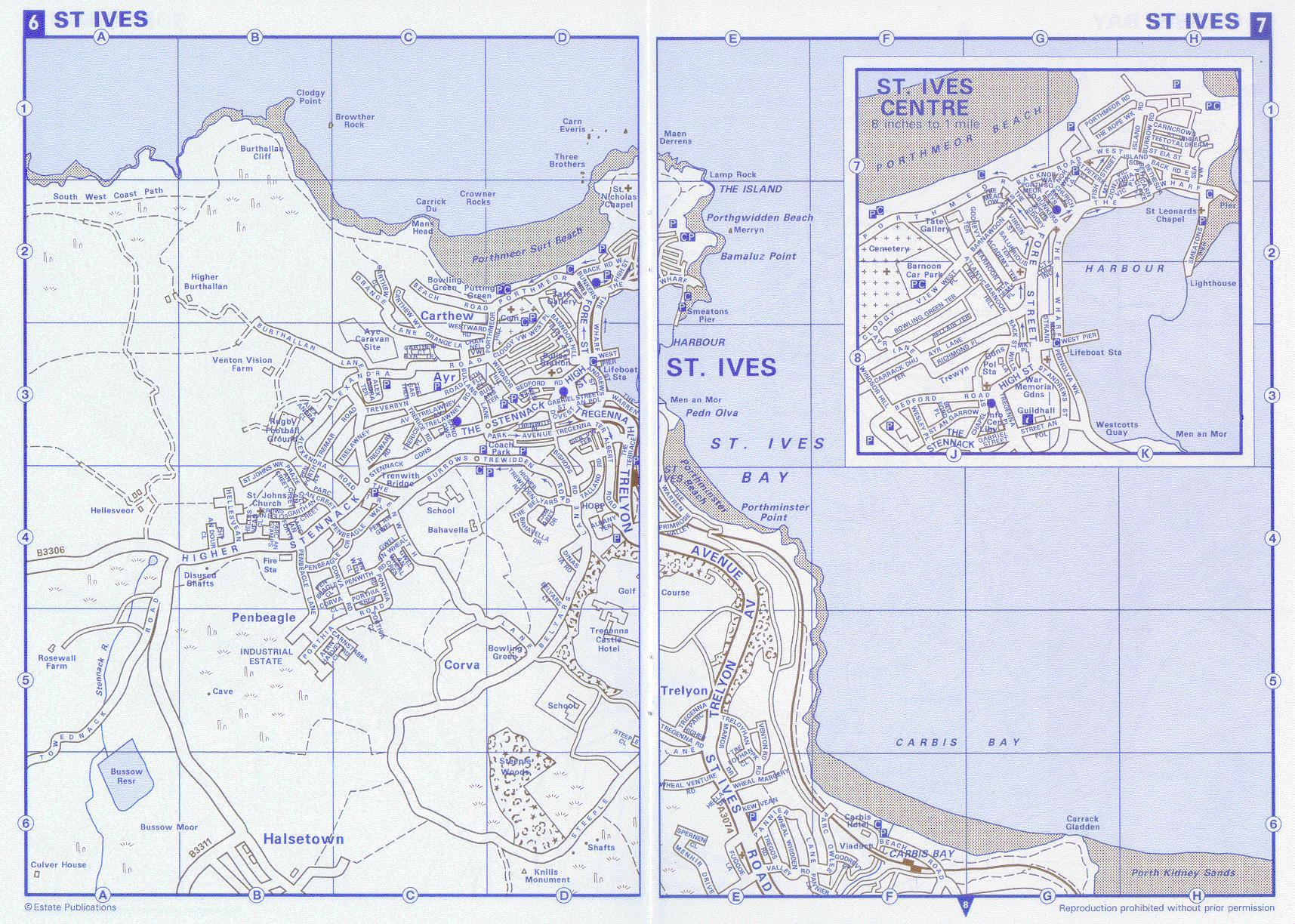
J8 (see insert) |
Named for the Nineteenth Century navigation school of James
'Teapot' Rowe! |
| Academy Terrace |
J7 (see insert) |
|
| Alan Harvey Close |
C5 |
Named after a former mayor. |
| Albany Terrace |
D4 |
|
| Albert Road |
D3 |
|
| Alexandra Close |
B3 |
|
| Alexandra Road |
B3 |
|
| Alexandra Terrace |
C3 |
|
| Atlantic Terrace |
J8 (see insert) |
Faces the Atlantic (oddly enough!). |
| Ayr Lane |
J8 (see insert) |
Nothing to do with Scotland. Seems to be either derived from 'Arth
Ia' - Ia's enclosure or 'Aire' meaning 'high place'. |
| Ayr Terrace |
C3 |
See above. |
| Back Road East |
K7 (see insert) |
Frequently mistaken for Back Road West ... |
| Back Road West |
D2 |
... and vice versa! |
| Back Street |
D3 |
Not to be confused with either of the above. |
| Bahavella Drive |
D4 |
'Nook by the apple tree'. |
| Baileys Lane |
K7 (see insert) |
Named after Captain Bailey. |
| Barnawoon |
J7 (see insert) |
|
| Barnoon Hill |
D3 |
'Top of the down'. |
| Barnoon Terrace |
J7 (see insert) |
See above. |
| Beach Road |
C2 |
|
| Bedford Place |
J8 (see insert) |
|
| Bedford Road |
D3 |
|
| Bellair Terrace |
J8 (see insert) |
|
| Belyars Court |
D4 |
Derived from 'bellyer' - bell ringer. |
| Belyars Lane |
D5 |
See above. |
| Belyars, The |
D4 |
See above. |
| Bethesda Hill |
K7 (see insert) |
Possibly named after the Pool of Bethesda
referred to in the Bible due to the similarity of the five porches of the
houses. |
| Bethesda Place |
K7 (see insert) |
See above. |
| Bishops Road |
D3 |
|
| Bowling Green Terrace |
J8 (see insert) |
|
| Bullans Lane |
C3 |
Possibly from 'bullace' (wild plum) or area once
referred to as 'Bull House Field'. |
| Bullans Terrace |
D3 |
See above. |
| Bunkers Hill |
D2 |
Named after the Battle of Bunker Hill during the
American War of Independence. |
| Burrow Road |
K7 (see insert) |
There is a house called 'The Hobbit' in St. Ives
but sadly it isn't in Burrow Road! |
| Burrows, The |
C4 |
|
| Burthallan Lane |
B3 |
|
| Camaret Drive |
D4 |
Camaret is a town in Brittany (France) which St.
Ives is twinned with. |
| Carncrows Street |
K7 (see insert) |
'Cross by the rocks'. |
| Carnglaze Place |
K7 (see insert) |
'Blue rock'. (Possibly a reference to the local
stone blue elvan, which is so hard even God walks in fear of it!). |
| Carnstabba Road |
C5 |
Stabba or Stabbe may be a name, hence 'Stabba's
Rock'. |
| Carrack Dhu Terrace |
J8 (see insert) |
'Carrack' is a rock and 'dhu' means black. |
| Carthew Close |
C2 |
A corruption of 'carrack dhu' or from 'caer dhu'
meaning 'black fort'. |
| Carthew Court |
C3 |
See above. |
| Carthew Way |
C2 |
See above. |
| Channel View |
C3 |
|
| Chapel Street |
J8 (see insert) |
|
| Church Place |
K7 (see insert) |
|
| Chy An Dour Close |
B4 |
House by the water. |
| Clodgy View |
D3 |
Believed to mean 'isolation hospital'. Clodgy Point may have
been a leper hospital. |
| Corva Close |
C4 |
From 'corvagh' meaning 'nook'. |
| Corva Road |
C4 |
See above. |
| Court Cocking |
J8 (see insert) |
Not, as often popularly assumed, the red light district!
Possibly where the 'cockyn' were kept. (These were the small boats used by
the seine fishermen). Or from the Cocking family. |
| Crows-an-Eglos |
B4 |
'Cross (or crossing) by the church'. |
| Digey, The |
J7 (see insert) |
Controversy rages over this one. Most commonly accepted
opinion is 'Dye House' relating to the treatment of nets to preserve them.
One alternative theory is that it refers to a 'farm house'. This might
seem odd in the middle of St. Ives but there is an area at one end of The
Digey called the Meadows, which is suggestive. |
| Dinas Ia Road |
D4 |
'Ia's Stronghold'. |
| Dove Street |
D3 |
|
| Fish Street |
D2 |
Used to be rows of fish cellars. |
| Fore Street |
D2 |
Until the Wharf was built out and a road put on
it this was the main street for getting down to shore. |
| Gabriel Street |
D3 |
|
| Garth An Creet |
B4 |
'Enclosure by the mound'. |
| Gill An Creet |
B4 |
|
| Gwel An Wheal |
C4 |
'Field by the mine'. |
| Gwel An Wheal Crescent |
C4 |
See above. |
| Hecla Drive |
E6 |
|
| Hellesvean |
B4 |
'Little slope'. |
| Hellesvean Close |
B4 |
See above. |
| Hicks Court |
J7 (see insert) |
|
| High Street |
D3 |
|
| Higher Stennack |
B4 |
See 'Stennack'. |
| Higher Tregenna Road |
E5 |
See 'Tregenna'. |
| Higher Trewidden Road |
D4 |
See 'Trewidden'. |
| Island Road |
K7 (see insert) |
The centre of the known universe. |
| Island Square |
K7 (see insert) |
Actually a triangle. |
| Kew Vean |
E6 |
'Little enclosure (or hollow)'. |
| Manor Drive |
E5 |
|
| Market Place |
J8 (see insert) |
Site of the original medieval market. |
| Market Strand |
J8 (see insert) |
|
| Meadow, The |
J7 (see insert) |
See note on The Digey. |
| Mount Zion |
K7 (see insert) |
Site of the nineteenth century Mount Zion
Chapel. |
| Norway Lane |
K7 (see insert) |
Nothing to do with Vikings it is basically northwards facing
hence, Nor' Way. |
| Norway Square |
J7 (see insert) |
See above. |
| Orange Lane |
C3 |
Yes, the climate is mild down here but it is
hard enough to grow any trees around here, let alone oranges! |
| Parc An Creet |
B4 |
'Field by the mound (or barrow)'. |
| Parc An Forth |
B4 |
'Field by the path'. |
| Parc An Stamps |
B4 |
'Field of the (tin) stamps'. |
| Park Avenue |
D3 |
|
| Pednolva Walk |
K8 (see insert) |
'Look-out headland'. |
| Pen An Gwel |
C4 |
'Top of the field'. |
| Pen Porth Avenue |
B4 |
'Top of the cove'. |
| Penbeagle Close |
C4 |
'Shepherds hill' (or 'top of the hill'). |
| Penbeagle Crescent |
B4 |
See above. |
| Penbeagle Lane |
B4 |
See above. |
| Penbeagle Way |
C4 |
See above. |
| Penwith Close |
C4 |
Penwith is the district St. Ives is in. The
exact meaning is uncertain but 'penwith' may mean 'extremity' and was
originally the name used for Land's End. |
| Penwith Road |
C4 |
See above. |
| Porthia Close |
C5 |
'Ia's Cove' (i.e. St Ives). |
| Porthia Crescent |
C4 |
See above. |
| Porthia Road |
C4 |
See above. |
| Porthmeor |
D2 |
'Big cove'. |
| Porthmeor Hill |
D2 |
See above. |
| Porthmeor Road |
J7 (see insert) |
See above. |
| Porthmeor Square |
K7 (see insert) |
See above. |
| Praze An Creet |
B4 |
'Meadow by the mound'. |
| Primrose Valley |
E4 |
|
| Rope Walk, The |
K7 (see insert) |
Where ropes were spun. |
| Rose Lane |
J7 (see insert) |
Possibly a corruption of Rowe's Lane, Mr. Rowe
being one of its earliest known residents or an ironic local reference to
a place that smelled rather bad. |
| St Andrews Street |
D3 |
St. Andrew and St. Peter were latter day
additions as patrons to St. Ia. (i.e. as usual the church couldn't bear to
have a woman in charge!). |
| St Eia Street |
K7 (see insert) |
'Eia' the original Celtic version of Ives before the
Anglo-Saxons got their spin doctors on the case. |
| St Ives Road |
E6 |
|
| St Johns Walk |
B4 |
|
| St Peters Street |
K7 (see insert) |
|
| Salubrious Terrace |
J7 (see insert) |
I'm not making these up, you know. Honest! |
| Sandows Lane |
C3 |
Named after a person. |
| Sea View Place |
K7 (see insert) |
|
| Sea View Terrace |
D3 |
|
| Smeaton's Pier |
K7 (see insert) |
The main pier, built by Mr. Smeaton. |
| Southfield Place |
C3 |
Literally where the south field was. |
| Steeple Close |
D5 |
See below. |
| Steeple Lane |
D6 |
The road up to the Knill Monument. |
| Stennack Gardens |
C3 |
See below. |
| Stennack, The |
C3 |
'The Tin Ground'. |
| Street An Garrow |
J8 (see insert) |
'Rough Street'. (Well, it is next to the Three
Ferrets). |
| Street An Pol |
D3 |
'Street by the Pool (or well)'. The lower end of
the street was once known as cut-throat alley! |
| Talland Road |
D4 |
|
| Teetotal Street |
K7 (see insert) |
It's in the No Alcohol Zone as well. |
| Terrace, The |
D3 |
|
| Towednack Road |
A5 |
Said to derive from the chapel of St. Tewennoc the
Confessor. |
| Tregarthen |
C3 |
Possibly 'House by the Mountain Ash' or
'Garthen's Dwelling'. |
| Tregenna Hill |
D3 |
'Dwelling at the entrance'. |
| Tregenna Parc |
E5 |
See above. |
| Tregenna Place |
J8 (see insert) |
See above. |
| Tregenna Terrace |
D3 |
See above. |
| Tregwary Road |
C3 |
|
| Trelawney Avenue |
C3 |
Arrr, Jim lad .... |
| Trelawney Road |
C3 |
|
| Treloyhan Close |
E5 |
'Dwelling in the grove'. |
| Treloyhan Park Road |
E5 |
See above. |
| Trelyon Avenue |
D4 |
Corruption of Treloyhan. |
| Tremar Road |
B3 |
|
| Trenwith Lane |
C4 |
'Dwelling by the trees'. |
| Trenwith Place |
D3 |
See above. |
| Trerice Place |
C3 |
'Farm by the ford'. |
| Trerice Road |
C3 |
See above. |
| Treverbyn Road |
C3 |
'Erbyn's Dwelling'. |
| Trewidden Road |
D3 |
'White farm'. |
| Venton Road |
E5 |
'Venton' is a well or natural spring. |
| Victoria Place |
K7 (see insert) |
Named after some Queen of England whose name
temporarily escapes me!
|